Landslides and Heavy Rainfall
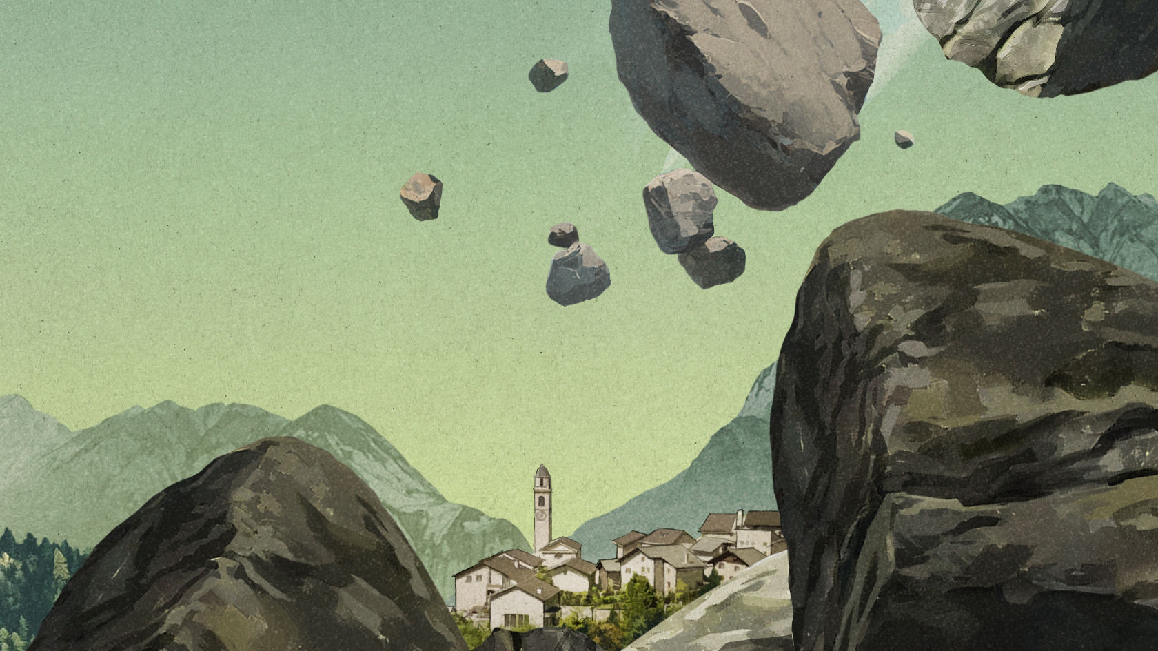
Early in the morning, some five-and-a-half million cubic meters of rock detached from the mountainside and crashed onto the glacier, sweeping away part of the glacial ice as they plunged into the valley below. The scree made up of ice and debris ended up stretching over more than five kilometers.
The landslide described here is similar in many respects to the one that occurred above Blatten in May 2025, which largely buried the small village in the Lötschental valley in the Valais. But this one happened over a year earlier, in April 2024, at the Piz Scerscen mountain above Pontresina in the Grisons. According to an analysis by the Swiss Federal Institute for Forest, Snow and Landscape Research WSL, it was the largest landslide in terms of rock volume in Switzerland since 1991, when a total of 30 million cubic meters of rock came crashing down into the valley in several waves in the village of Randa in the Valais. The one at Piz Scerscen attracted little media attention, however. This is because the fall zone wasn’t populated, so there were no casualties and no damage to infrastructure.
An unexpected rockslide
“The rockslide at Piz Scerscen came unexpectedly,” says Holger Frey, a geographer who specializes in natural hazards in alpine regions. “There was literally no warning.” Although the area is in a remote location at the far end of the Val Roseg valley, it was pure chance that no one was hurt, as a number of popular hiking trails and ski touring routes cross the fall zone. It was sheer coincidence that no one was about when the landslide occurred during a period of fine weather.
This was a landslide that was completely unexpected and fortunately didn’t claim any lives. Meanwhile, the incident in Lötschental involved a whole village being evacuated as a precaution and one person losing their life. These two examples illustrate that many factors dictate whether natural disasters can be predicted and what impact they have. “In Blatten, the precautionary measures worked as the Nesthorn mountain and the Birch glacier had already been under observation for a long time,” says Frey. However, as the Piz Scerscen case shows, far from all potential sources of danger can be detected.
In its current climate risk analysis for Switzerland, the Federal Office for the Environment (FOEN) classifies landslides as one of the most significant risks of climate change in the alpine area. The FOEN expects natural hazards, which up to now have been very rare, to occur more frequently. However, the report puts this into perspective, indicating that the impact will mostly be limited to local areas.
More instability
If we take a look at major landslides in Switzerland, they do seem to be occurring more frequently in recent years: before Blatten and Piz Scerscen, large masses of rock plunged into the valley in various locations in 2023, 2017 and 2011. These incidents claimed lives, and destroyed homes and infrastructure. Can we see this as a very real impact of climate change?
Frey doesn’t see these cases as evidence of a clear trend, as they occur too rarely. “It could also just be coincidence.” In principle, says Frey, there are three key factors at play in a landslide: the composition of the rock, the terrain and the underground temperature. While the latter has measurably increased in recent years as a result of climate change, the other two factors haven’t changed.

The warming we’re seeing in the air can now also be detected several dozen meters underground, as shown by permafrost measurements.
“The warming we’re seeing in the air can now also be detected several dozen meters underground, as shown by permafrost measurements,” says Frey. However, it’s difficult to gage how this warming impacts the hazard situation in concrete terms. This is because ultimately many different factors have to coincide to cause large masses of rock to come loose. “Warming does tend to weaken the structures though.”
Simulating future incidents
In his research, Holger Frey studies what could happen if debris, ice or water start moving. He is developing a model of how rockslides, ice avalanches and water masses spread over the terrain, and where and how water and debris flow. These findings help predict where critical incidents could occur and how people can protect themselves from the impact.
“We are able to reconstruct and analyze real rockslides after the event very effectively using models,” he explains. This helps us gain a better understanding of the processes involved. On the basis of these models, scenarios for potential future incidents can also be simulated. “The challenge is feeding these models with data that is as realistic as possible,” explains Frey.
How much rock could fall? How much water gushes out of a glacial lake? How much debris would it take with it? Just as important as assessing the damage potential is being able to predict the likelihood of such events occurring at all. At present, there is not enough reliable data to do this. Frey is therefore working on compiling and analyzing as much data as possible on rockslides from all over the world. This can be used to derive the probabilities of an incident on this scale occurring in a comparable region in the next 10 or 100 years.
Extreme precipitation
It is not only landslides and rockfalls that pose risks, the FOEN report on climate risks also lists smaller-scale, localized flooding as a climate risk. “Usually, flooding is triggered by rainfall,” says Daniel Viviroli from UZH’s Department of Geography, whose research interests include the impact of climate change on flooding.
And this has measurably increased in recent decades. According to statistics from the Federal Office of Meteorology and Climatology (MeteoSwiss), heavy rainfall in Switzerland became both more intense and more frequent between 1901 and 2023. In particular, the intensity of short periods of heavy rainfall has increased over the last 40 years, while the intensity and frequency of prolonged periods of rainfall have decreased.

The fact that rainfall is heavier when temperatures rise can be explained by physics: The warmer the air, the more moisture it can hold.
The fact that rainfall is heavier when temperatures rise can be explained by physics, says Viviroli. This is because the warmer the air, the more moisture it can hold, with humidity increasing by six to seven percent per degree of warming. If it rains, there is simply more water vapor in the air that can be rained out.
How that then impacts flooding is less clear, however. Because here too, an interplay of many factors determines whether or not extreme precipitation leads to major flooding. How high is the zero-degree line? How much water is already in the ground? Is the water level of the rivers high due to snow melt? How much space does the river have?
Planning bridges and dams
Making reliable predictions about the frequency of future floods in a specific region is therefore difficult. Simulations and models can help here, too. For example, Viviroli and his team have modeled the run-off characteristics of Switzerland’s rivers using real weather data from the last 90 years. These models help us understand how often flood peaks occur and what proportions they can take.
Based on this, the researchers also carried out simulations over several hundreds of thousands of years using artificially-generated weather data. This allows them to assess the extremely rare events that statistically only occur every 100 or even 1,000 years. The question of how much more significant floods will become due to climate change is difficult to answer, and more detail is needed in the climate scenarios, particularly for short periods of heavy rainfall.
This uncertainty is a challenge, for example when planning bridges, dams and other mitigation measures, says Viviroli. On which scenarios should they be based and for what volumes of water do they need to be designed? “Of course, we could just increase the values by a certain factor in the calculations,” says Viviroli. But obtaining reasonably reliable predictions from this is impossible due to the complexity of the processes.
More space for rivers
One example of an effective flood protection measure is giving rivers more space by widening the riverbed. If a major flooding event occurs, this additional space can mitigate the flood peak. “But there are often conflicts of interest here, as it’s usually agricultural land that has to be given up,” says Viviroli.
This is because ultimately natural hazard protection is also a question of weighing up economic and political considerations. Major flood events play an important role here. For example, following heavy flooding in 1987 and 2005, it wasn’t only spatial planning that was adapted, but investment was also bolstered in storm and flood prevention and early warning systems. One of the projects was a planned flood protection zone covering a distance of 162 kilometers along the Rhine.
The long-term project is set to take several decades and will end up costing a total of CHF 3.6 billion. The measures are designed to save hundreds of thousands of people from flooding and prevent ten billion Swiss francs’ worth of damage. But the political will to spend money on such projects and to repurpose land is not always there. This is why it’s all the more important for scientists to provide robust evidence on which to base risk and cost assessments.